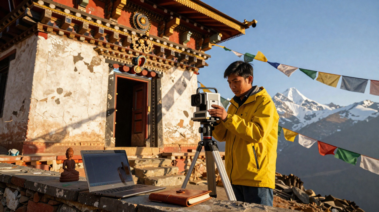
Nepal’s high-altitude Himalayan monasteries are beginning to fail under changing weather, thawing earth and the passage of time. A rising generation of digital custodians is working to record them in 3D before rockfalls, wind and gravity decide their fate.
At first light, a monk in weathered maroon robes folds a prayer flag and acknowledges visitors laden with tripods and battery packs, their breath visible in the cold air. Within the shadowy gompa, butter lamps murmur while an ochre wall reveals old blues and gold leaf, speckled by soot and windblown snow dust.
A laptop stirs into life on a woollen rug. Its first laser pass is silent but relentless, turning the room into an assembling apparition of data points. At the entrance, a drone buzzes as the wind tugs at its rotors like a child pulling a kite string. The monk looks at the display, his eyes bright as a doorway resolves into a precise cloud of dots.
The past appears, pixel by pixel.
Racing the mountain: why 3D scans can’t wait
The Himalayas are never static. Roof timbers expand and crack, clay mortar crumbles away, and foundations move as permafrost thaws and rainfall grows more intense. A monastery that has remained stable for three centuries may begin to lean after a single abnormal monsoon season. A laser can freeze a monastery in time, but it cannot stop the mountain.
The 2015 earthquakes damaged thousands of heritage buildings throughout Nepal, from urban squares to chapels perched on cliffs. In Mustang and Dolpo’s high valleys, beyond the end of the road and along the first stretches of trail, teams from local universities and international organisations including the Nepal Heritage Documentation Project and CyArk started transporting LiDAR equipment and drones by mule. One group documented a 14th-century temple where murals peeled away like pastry. Its scan provided conservators with a detailed record of vulnerable areas in the wall, informing roof repairs that prevented a winter leak from wiping out a century of painted work.
The principle is straightforward. Photogrammetry creates a 3D model from overlapping photographs, while LiDAR uses light to measure millions of distances and remains sharply accurate even in dark interiors. Used together, they supply structural geometry and artistic texture. Engineers can carry out stress testing on the digital twin, while curators can inspect brush marks finer than a thread. Communities receive copies too, sometimes stored offline on an inexpensive tablet, so children can learn the stories of the spaces in which they worship. It is, in effect, protection against a loss everyone hopes will never happen.
Capturing Himalayan monasteries when the wind pushes back
Begin with permission, tea and patience. Meet the caretaker or lama, describe what scanning involves, ask which places must not be photographed, and explain where the data will be stored. Next, plot the route as though it were a pilgrimage: work from outside to inside, from roof down to floor, and move clockwise through each room. Photograph at dawn or late afternoon, when the light is gentler. Allow substantial overlap-around 70 to 85 per cent-and work slowly, keeping the camera perpendicular to the surface. Keep spare batteries warm beneath your jacket, because cold drains their charge.
To reduce problems in the mountains, make every part of the process redundant. Carry two SD cards, two portable drives and two people who understand the workflow. Establish scale with coded targets or an ordinary steel tape visible in the image. Keep murals out of harsh midday glare, and use polarising filters where available. Make backups before bed, even when your hands are too numb to cooperate. Realistically, no one manages this every day. Yet the night you decide not to do it will be the night a storm takes the tent.
“We’re not saving stones, we’re saving choices,” says Suman, a conservation engineer who grew up near Pokhara. “When the wall moves or the paint flakes, a good scan gives us options that weren’t there yesterday.”
- Use clear, plain-language consent: decide what can be shared publicly, what remains private and who controls access.
- Pair low-tech with high-tech: small printed photo panels help involve elders who do not use phones, changing the nature of the discussion.
- Record everyday details: thresholds, soot-darkened beams and nail holes. Future repair teams will be grateful.
- Maintain a field log in both the local language and English: brief, clear and human.
What pixels can preserve-and what they cannot
A digital record is no replacement for a pilgrimage. A point cloud cannot convey the scent of juniper smoke or the stillness before chanting begins. But a scan can create a connection across a long winter, a landslide or a border crossing. Most people know how a photograph from home can make them feel steadier. Picture that memory in three dimensions: the camera moves as your eyes would, and the floor remembered wobbling beneath your boots remains secure on a screen.
There are also dangers. Data sovereignty is crucial: who is permitted to download a monastery, and where does it travel online? Communities are concerned about virtual theft and tourism that transforms worship into a spectacle. Data without community consent isn’t preservation, it’s extraction. The strongest projects establish sharing agreements with local people, keep files on Nepali servers where feasible, and teach residents to scan their own sites. In this way, the sacred does not become a screensaver on somebody else’s laptop.
Technology is a tool rather than the narrative. A promising future does not mean a VR headset for every person; it means a durable temple with a watertight roof, a digital backup controlled by those who pray there, and a map that allows masons to place the next stone safely. In Kathmandu, children already explore virtual gompas made from real scans, learning the names of deities and carpentry joints at the same time. The true archive is still in the hands of the people who light the lamps.
Nothing in the Himalayas endures by chance. Monasteries survive because people continually care for them: repairing clay, renewing a beam and repainting a lotus petal by petal. 3D scanning becomes part of that sequence of care, a modern implement in an ancient toolbox that is valuable when used humbly. It can help secure donor support through before-and-after comparisons, enable insurers to understand exposure to risk, and allow a mason to measure a distorted truss without leaving the village. It can equally encourage complacency if a file is mistaken for the thing itself. The mountain will continue to pose its questions; the task is to arrive with stronger answers and warmer gloves.
| Key point | Detail | Why it matters to readers |
|---|---|---|
| Digital twins of vulnerable gompas | LiDAR and photogrammetry record structures and murals at millimetre scale | Learn how scans safeguard art and inform safe repairs |
| Community-first data | Consent, local hosting and shared model ownership | Understand how heritage remains with its communities, rather than existing only in the cloud |
| Practical field guidance | Lighting, overlap, backups, scale targets and respectful workflows | Useful steps for volunteering, donating equipment or joining a mission |














Comments
No comments yet. Be the first to comment!
Leave a Comment